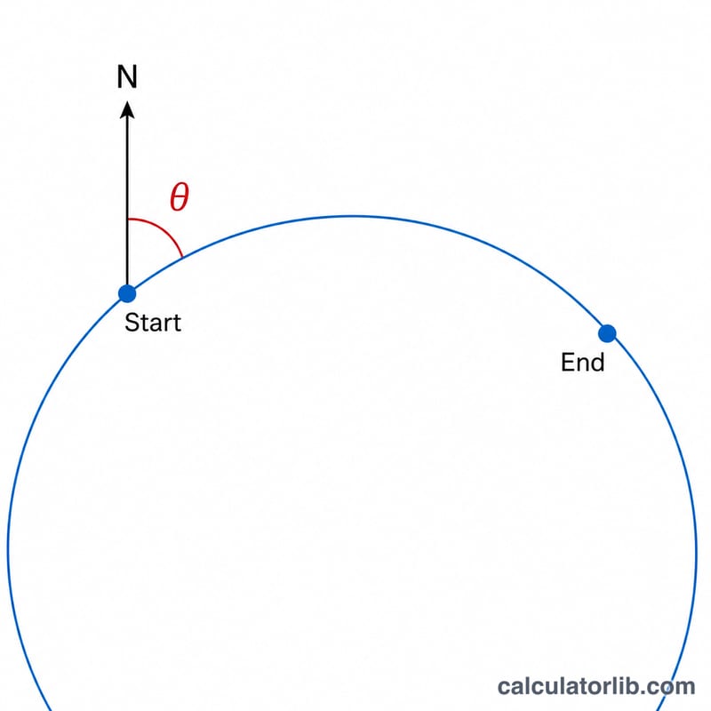
What is the bearing between two points?
The bearing (or forward azimuth) between two geographic points is the compass direction you would head, measured clockwise from true north, to travel along the shortest great-circle path from a start coordinate to a destination coordinate. It is expressed in degrees from 0° (due north) through 90° (east), 180° (south) and 270° (west). This calculator works anywhere on Earth using latitude and longitude in decimal degrees.
How to use this calculator
Enter the latitude and longitude of your starting point and your destination point in decimal degrees. Use positive values for north and east, and negative values for south and west (for example, 40.7128, -74.0060 for New York City). Press calculate to get the initial bearing in degrees plus the nearest 16-point compass direction.
The formula explained
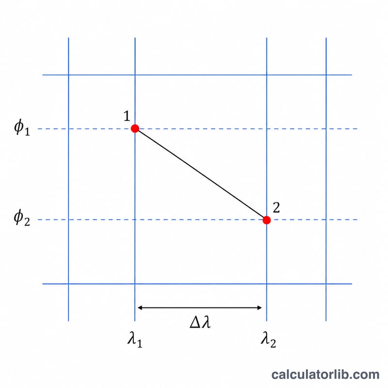
The initial bearing is computed with the spherical-trigonometry formula $$\theta = \operatorname{atan2}\left(\sin\Delta\lambda\cdot\cos\varphi_2,\; \cos\varphi_1\sin\varphi_2 - \sin\varphi_1\cos\varphi_2\cos\Delta\lambda\right),$$ where \(\varphi_1\) and \(\varphi_2\) are the latitudes, and \(\Delta\lambda\) is the difference in longitude, all in radians. The two-argument atan2 function returns the correct angle in every quadrant; we then convert to degrees and add 360, taking the modulo 360 so the result always falls between 0° and 360°. Note this is the initial bearing — along a great-circle route the bearing changes continuously, so the final bearing at the destination differs.
Worked example
From Land's End (50.066389, -5.714722) to John o' Groats (58.643889, -3.07): plugging the values into the formula gives an initial bearing of about \(9.12^{\circ}\), which rounds to a compass direction of N (north). Heading just east of due north matches the layout of Great Britain.
Compass Point Reference Table
A bearing is most often expressed as a value from \(0^{\circ}\) to \(360^{\circ}\) measured clockwise from true north. The 16-point compass rose divides the full circle into equal sectors of \(360^{\circ} / 16 = 22.5^{\circ}\). Each named point is centered on a multiple of \(22.5^{\circ}\) and spans \(\pm 11.25^{\circ}\) around that center.
| Point | Abbr. | Center Azimuth | Degree Range |
|---|---|---|---|
| North | N | 0° | 348.75°–11.25° |
| North-Northeast | NNE | 22.5° | 11.25°–33.75° |
| Northeast | NE | 45° | 33.75°–56.25° |
| East-Northeast | ENE | 67.5° | 56.25°–78.75° |
| East | E | 90° | 78.75°–101.25° |
| East-Southeast | ESE | 112.5° | 101.25°–123.75° |
| Southeast | SE | 135° | 123.75°–146.25° |
| South-Southeast | SSE | 157.5° | 146.25°–168.75° |
| South | S | 180° | 168.75°–191.25° |
| South-Southwest | SSW | 202.5° | 191.25°–213.75° |
| Southwest | SW | 225° | 213.75°–236.25° |
| West-Southwest | WSW | 247.5° | 236.25°–258.75° |
| West | W | 270° | 258.75°–281.25° |
| West-Northwest | WNW | 292.5° | 281.25°–303.75° |
| Northwest | NW | 315° | 303.75°–326.25° |
| North-Northwest | NNW | 337.5° | 326.25°–348.75° |
North straddles the \(0^{\circ}/360^{\circ}\) boundary, so its range wraps around from \(348.75^{\circ}\) through \(0^{\circ}\) to \(11.25^{\circ}\).
How to Calculate Bearing by Hand
This worked example finds the initial great-circle bearing from Land's End, England (\(\varphi_1 = 50.07^{\circ}\,\text{N},\ \lambda_1 = -5.72^{\circ}\)) to the Lizard Point area at (\(\varphi_2 = 49.96^{\circ}\,\text{N},\ \lambda_2 = -5.20^{\circ}\)).
- Convert the latitudes and longitudes to radians. Multiply each degree value by \(\pi/180\):
\(\varphi_1 = 50.07 \times \tfrac{\pi}{180} = 0.87388\ \text{rad}\), \(\varphi_2 = 49.96 \times \tfrac{\pi}{180} = 0.87196\ \text{rad}\), \(\lambda_1 = -5.72 \times \tfrac{\pi}{180} = -0.09984\ \text{rad}\), \(\lambda_2 = -5.20 \times \tfrac{\pi}{180} = -0.09076\ \text{rad}\). You can confirm a single conversion such as 0.87388 rad. - Compute the longitude difference \(\Delta\lambda = \lambda_2 - \lambda_1\):
\(\Delta\lambda = -0.09076 - (-0.09984) = 0.00908\ \text{rad}\) (equivalently \(+0.52^{\circ}\)). - Compute the atan2 numerator \(y = \sin(\Delta\lambda)\,\cos\varphi_2\):
\(y = \sin(0.00908)\times\cos(0.87196) = 0.00908 \times 0.64323 = 0.005840\). - Compute the atan2 denominator \(x = \cos\varphi_1\sin\varphi_2 - \sin\varphi_1\cos\varphi_2\cos(\Delta\lambda)\):
\(x = (0.64154)(0.76568) - (0.76709)(0.64323)(0.99996)\)
\(x = 0.49121 - 0.49335 = -0.002143\). - Apply atan2 to get the angle in radians:
\(\theta = \operatorname{atan2}(0.005840,\ -0.002143) = 1.91898\ \text{rad}\). - Convert radians to degrees by multiplying by \(180/\pi\):
\(\theta = 1.91898 \times \tfrac{180}{\pi} = 109.95^{\circ}\). - Normalize to the \(0^{\circ}\)–\(360^{\circ}\) range with \((\theta + 360)\bmod 360\):
\((109.95 + 360)\bmod 360 = 109.95^{\circ}\).
The initial bearing is therefore about \(110^{\circ}\) — an east-southeast (ESE) heading. The normalization step matters when atan2 returns a negative value (for example a result of \(-70^{\circ}\) becomes \(290^{\circ}\)).
FAQ
Is this the same as a straight line on a flat map? No. This is the great-circle (shortest-path) bearing on a sphere, which differs from a constant-heading rhumb line and from straight lines on flat projections.
Does the bearing stay constant during the trip? No, for great-circle routes it changes along the way. This tool reports the bearing at the starting point.
What coordinate format should I use? Decimal degrees. Convert degrees-minutes-seconds first, and use negatives for south latitudes and west longitudes.